

Vendor » Esri
Features

Esri Melds GIS with AI, Graph, and Analytics
Esri has long been the industry leader in geographic information systems (GIS), which are used by urban planners, building engineers, and landscape designers around the world. At its UC 2022 conference this week, the com Read more…

Esri Puts Federal Climate Change Action on the Map
What is the Federal Government doing about climate change? Quite a bit, it turns out, but nothing tells a story quite like a map, which is why the Feds are using geospatial information systems from Esri to track the chan Read more…

Esri Simplifies Developer Access to Location Data with ArcGIS Platform
Esri built a solid reputation in the geographic information services (GIS) world with its flagship ArcGIS offering. Now the company is expanding its business model and catering to Web and mobile developers with a slew of Read more…

Esri Boosts ‘Velocity” of ArcGIS for IoT
Esri, the location intelligence and geospatial analytics specialist, is accelerating its Internet of Things analytics platform as more industries integrate geospatial sensor data and real-time analytics into their operat Read more…

Getting Creative with COVID-19 Contact Tracing
What do a GIS, a SIEM, and a time and attendance system have in common? If you said they’re all being used to help trace potential COVID-19 infections in American schools and workplaces, then give yourself a gold star. Read more…

Kroger Tackles Childhood Hunger at Home with Geo-Analytics
Hunger is on the rise around the world, thanks to the COVID-19 pandemic and the economic recession stemming from it. One company that is stepping up to the plate is The Kroger Co., which recently directed its data scienc Read more…
New Map Shows Hundreds of Counties in the COVID-19 Endgame — and Thousands on the Uptick
As more and more states around the country begin to loosen the lockdowns that have kept most Americans inside for upwards of two months, people are waiting with bated breath for the dreaded second peak that some research Read more…

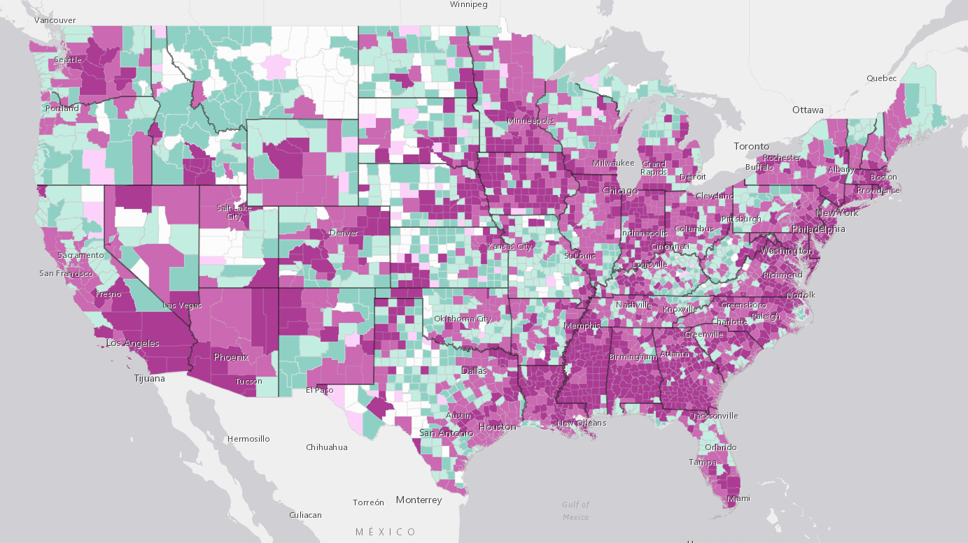
Community Transmission: Counties Are the Front Lines in Virus Battle
The foot soldiers in the battle against COVID-19 are increasingly relying on location data to track resources and stem the spread of the virus, often one county at a time. With much of the responsibility for public sa Read more…
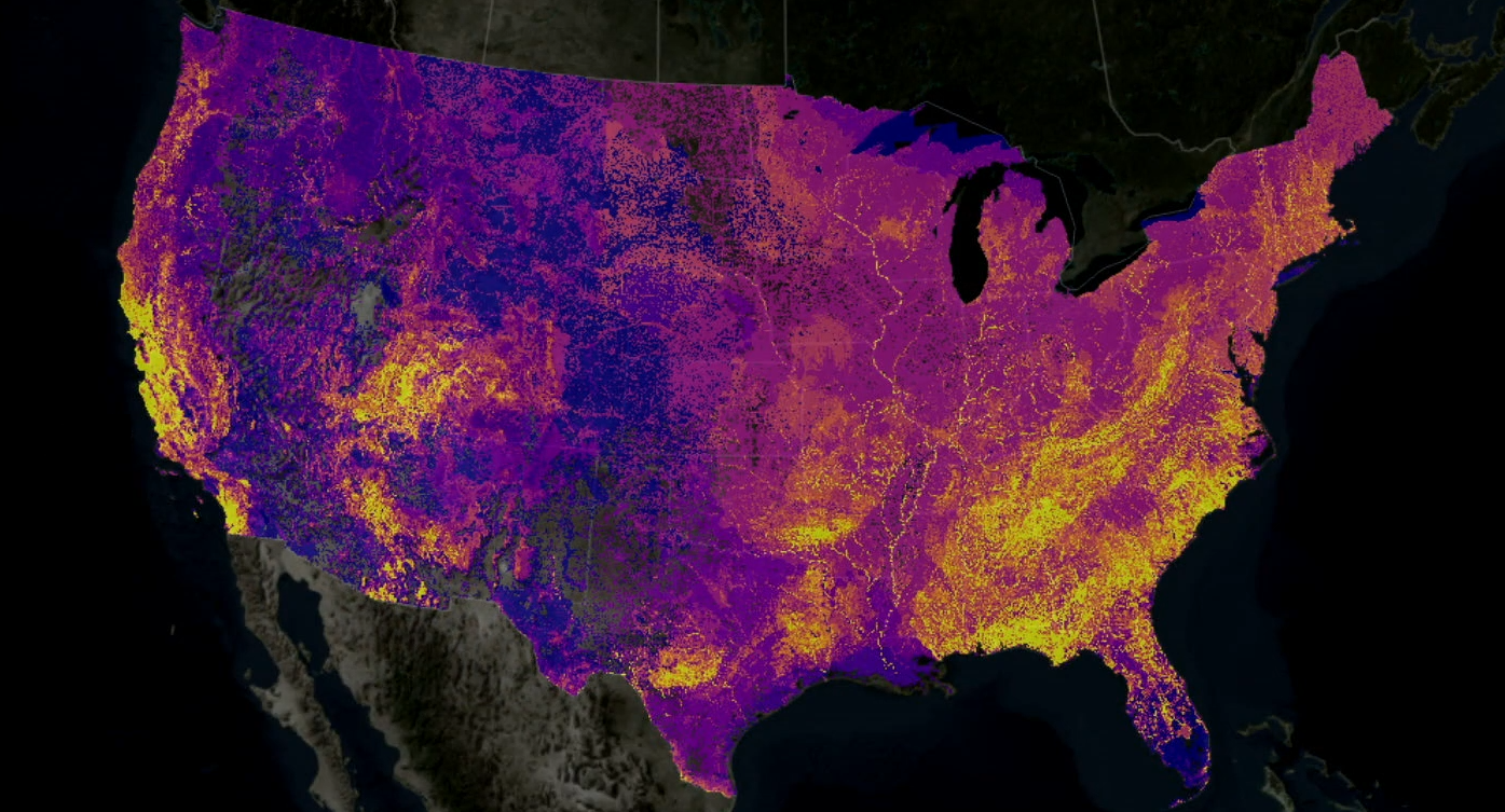
Big Data and AI Converge in Map to Protect Biodiversity
What's living where? Those are the basic pieces of data that biologists and conservationists are hoping to collect and load into the Map of Biodiversity Importance, a dynamic new map unveiled this week at the Esri User C Read more…

Drone Data Ecosystem Growing Fast, Report Says
The ecosystem that's emerged around the collection and analysis of data from drones is growing very quickly, according to a new report issued by DroneDeploy, one of the companies operating in the space. According to D Read more…
This Just In
Feb 12, 2024 |
REDLANDS, Calif., Feb. 12, 2024 — On February 14, 2024, Esri, a global leader in geographic information system (GIS) technology, is hosting the Federal GIS Conference at the Walter E. Read more…
Jan 25, 2024 |
REDLANDS, Calif., Jan. 25, 2024 — This week marks the launch of Maps.com, a groundbreaking platform dedicated to showcasing and celebrating the world’s most beautiful and remarkable maps. Read more…
Nov 17, 2023 |
REDLANDS, Calif., Nov. 17, 2023 — In 2021, Esri, a global leader in location intelligence, released ArcGIS Platform, a geospatial platform as a service (PaaS) for developers to integrate location capabilities into their apps, business systems, and products. Read more…
Nov 14, 2023 |
REDLANDS, Calif., Nov. 14, 2023 — Digital transformation is rapidly changing the foundational processes powering the architecture, engineering, and construction (AEC) sectors. Industry leaders are relying on the interoperability of geographic information systems (GIS) and building information modeling (BIM) to reduce costs and boost efficiency across construction projects. Read more…
Nov 9, 2023 |
REDLANDS, Calif., Nov. 9, 2023 — Organizations in national, state, and local governments; architecture, engineering, and construction (AEC) sectors; and more are implementing 3D workflows for everything from asset monitoring to risk analysis. Read more…
Oct 3, 2023 |
REDLANDS, Calif., Oct. 3, 2023 — For nearly a decade, ArcGIS Pro has been an essential desktop application for GIS users to explore, visualize, and analyze data in a spatial context. Read more…
Jul 13, 2023 |
REDLANDS, Calif., July 13, 2023 — From COVID-19 and elections to international political conflicts like the war in Ukraine, almost every current event and issue is shaped and framed by geographic elements. Read more…
Jul 10, 2023 |
REDLANDS, Calif., July 10, 2023 — Land-use/Land-cover (LULC) maps contextualize and quantify the impacts of earth processes and human activity on the environment. Organizations around the world are now using these tools to inform policy and land management decisions around issues like sustainable development. Read more…
Jun 29, 2023 |
REDLANDS, Calif., June 29, 2023 — Data scientists must often transform gigabytes or terabytes of data—collected from trillions of sources—into valuable insights by finding new ways to make their data work harder. Read more…
Jun 2, 2023 |
REDLANDS, Calif., June 2, 2023 — Students across the nation learn about environmental and social concerns every day not just in the classroom, but from the communities in which they live. Read more…
Leading Solution Providers


Tabor Network
Sponsored Multimedia


Featured Events
-
AI & Big Data Expo North America 2024
 June 5 - June 6Santa Clara CA United States
 -
CDAO Canada Public Sector 2024
 June 18 - June 19
 -
AI Hardware & Edge AI Summit Europe
 June 18 - June 19London United Kingdom
 -
AI Hardware & Edge AI Summit 2024
 September 10 - September 12San Jose CA United States
 -
CDAO Government 2024
 September 18 - September 19Washington DC United States